
Windsor Watchers · · Crime Map
Crime Map
Figures last checked . Official 2026 counts only. No estimates.
Official 2026 reported-incident counts for Windsor-Essex, by area. Windsor is shown by municipal ward. Every figure comes from a police report and links back to it. Date ranges vary by police service and are labelled on each area. Where a municipal count is official, the tooltip also shows incidents per 1,000 residents using Census 2021 populations, and a same-period 2025 comparison when that column printed cleanly in the source report. Areas without official 2026 figures are hatched and labelled "Data requested." This map shows official 2026 figures only and never fills a gap with an estimate. Crime Catcher pins show official 2026 police releases at block or neighbourhood level, never a home address. Open missing person alerts appear as a cyan pin and a banner above the map, and those pins are removed the same day the person is found or the official notice is taken down.
Date range: 2026 official figures; periods vary by area (see table) | Showing: All reported incidents
Filter the map
Off by default. When on, areas are shaded by mapped 2026 serious-crime pins per 1,000 residents, not by official police-report totals. Rates use mapped cases only, not all police-reported crime. Small towns can swing a lot from one or two cases.
Categories follow the Windsor Police Service monthly report. The Town of Essex OPP report uses the same broad groups where it prints them, and leaves a category blank where it does not. LaSalle has an official January 2026 statistics snapshot, not a category table. Lakeshore (including Belle River), Tecumseh, Kingsville, Leamington and Pelee stay unchanged by these count filters until a 2026 municipal table is published. Quick picks also filter Crime Catcher pins by type, so every pin type on the map has a pick. Picks that match a report category still change the area counts. Weapons, Violence, Sexual and child offences, Driving, Wanted, Outlaw motorcycle gang, and Other filter pins only and leave the area counts on the category already chosen. Month buttons filter pins to that month of 2026. All of 2026 shows every 2026 pin, including any after Oct 31, and pins whose official release did not give a day. Official area counts switch to the October report only when October is selected. Other months do not invent municipal totals, so the area shading stays on the official Jan 1 to Oct 31, 2026 figures.
Last checked 11 Nov 2026
Legend
Selected area
Pins in this view
The list follows the area, type and month you picked above. Near me uses your browser's location on this device only, to centre the map and sort the list. It is never sent to Windsor Watchers and never saved.
Trends: this month vs last month
Counts are Crime Catcher pins by incident date: official 2026 police releases with a public location. They are not the full police count of crime, and a change from one month to the next can reflect how many releases police published. Pins whose release gave no day are left out of monthly counts. Missing person alerts are not counted. The official monthly totals are in the table further down this page.
Report cards by area
Every ward and town has its own page: pins by type of crime, month by month change, case status and our stories. Each page has its own link to share.
- WindsorReport card
- Ward 1Report card
- Ward 2Report card
- Ward 3Report card
- Ward 4Report card
- Ward 5Report card
- Ward 6Report card
- Ward 7Report card
- Ward 8Report card
- Ward 9Report card
- Ward 10Report card
- AmherstburgReport card
- LaSalleReport card
- TecumsehReport card
- LakeshoreReport card
- Belle RiverReport card
- EssexReport card
- KingsvilleReport card
- LeamingtonReport card
- PeleeReport card
Alert me for my area
Pick your areas and get one free roundup a day for them, only on days when new pins land there.
Phone alerts (free)
Through the free Windsor News app. No app store and no account. Only the area names you pick are saved with your alert, never your location. Turn it off any time in the app.
Turn on the daily roundup for these areasTelegram (free)
Our Telegram channel posts desk alerts for all of Windsor-Essex. Telegram cannot filter by area.
Join on TelegramAlerts are not an emergency service. If someone is in danger now, call 911. Windsor Watchers is an independent news desk, not a police service.
Open data
Download every public pin so you can check our work. Public fields only: no card summaries, names, photos or missing person alerts.
Every area, as printed
| Area | All reported incidents | 2026 date range | Police | Official source |
|---|
How to read this map
- These are counts of reported incidents, not rates. Wards differ in size, population and how many people work or shop there, so a busier ward is not the same as a more dangerous one.
- Shades compare Windsor's 10 wards and Amherstburg only, because they come from the same Windsor Police Service report and the same date range. The five shade bands split those 11 areas into roughly equal groups for the filter you pick.
- Category rows do not always add up to the report total, because the total includes violation groups the report does not break out. Every figure is shown as printed.
- Ward totals add to 13,006 for Jan 1 to Oct 31, 2026. The City of Windsor only table prints 13,364. The report does not explain the 358 difference.
- A November 2026 Windsor Police Service report is not yet published for 2026. We checked the open data page on Nov 11, 2026.
- Town of Essex: official OPP Detachment Board Report for September 2026, location code 4E40. The year-to-date tables cover Jan 1 to Sep 30, 2026. The report does not print a single all-incidents total, so that filter shows the four printed group totals instead. No October 2026 municipal report was posted as of Nov 10, 2026.
- LaSalle: official January 2026 monthly statistics (CAD calls for service and RMS occurrence reports) from the March 16, 2026 Police Services Board agenda. Later public agendas through Nov 2, 2026 (including June 8, September 21 and November 2) were checked again and still had no February to October 2026 monthly statistics tables. Category counts were not printed in that January table.
- Lakeshore (including Belle River), Tecumseh, Kingsville, Leamington and Pelee: no official 2026 reported-incident table by municipality was found. Combined Essex County OPP reports are not assigned to any one municipality. They stay hatched and labelled "Data requested." Belle River is labelled on the map as a community in Lakeshore. No separate Belle River count is estimated.
- Crime Catcher pins are separate from the counts. Each pin is one official 2026 police release with a public location: Windsor Police Service news releases, Essex County OPP posts on the official OPP West Region account, and LaSalle Police Service news posts. Pins are not a full count of crime in an area, and an area with few pins is not necessarily safer. Pelee has no pins because no 2026 release with a public location was found. Pin colour and letter show the type of crime (use the legend or the "Type of crime" menu to filter), and each card shows the police service. Sexual offence, child protection and human trafficking pins are neighbourhood or town level only, with no details that could identify anyone harmed.
- Missing person pins use a bright cyan "M" marker, with their own legend entry and filter. They sit at the official last-seen area only, at block or neighbourhood level, never a home address. The card shows only what police published (photo, name, age, description, last seen date, time and place, and the official source), and asks people who have seen the person to call 911 or the issuing police service. If the person is found or police take the notice down, the pin, name and photo are removed the same day. That is an exception, for missing persons only, to the usual rule that pins stay on the map.
- A neighbourhood pattern pin (violet "P") is added only after a written yes, when a private close log shows 3 or more missing person reports in the same neighbourhood within 12 months. The public pin says "Pattern: repeated missing person reports in this area" and shows the count. It has no name, photo or other personal details, and it stays on the map.
- Outlaw motorcycle gang pins use a generic motorcycle icon, with their own legend entry and filter, never a club logo or patch. A club is named on the card only when police, the CBSA, a court or the Crown officially named it in the linked release. A club patch is shown only if that official release itself published a photo of seized vests or colours. Locations are block, street, neighbourhood or town level, never a home address.
- Each pin card shows which police service reported it, with a link to the release, whether the desk checked it against that source, and a status: Reported, Charged, Arrested, Court date or Resolved. A status is set only when the linked official release says so. Otherwise the pin says Reported. Court dates and outcomes are not tracked yet.
- Nearby pins are grouped into a numbered circle when the map is zoomed out. Zoom in or click the circle to see each pin. Untick "Group nearby pins" to see every pin at once.
- When official municipal counts are shown, incidents per 1,000 residents in those tooltips use Statistics Canada Census 2021 populations for that municipality. A one-month snapshot (LaSalle, January) is labelled as such and is not an annual rate. A separate, off-by-default "Per 1,000 residents" layer shades areas by mapped 2026 Crime Catcher pins per 1,000 residents, including Windsor wards. Ward populations for that layer come from the City of Windsor 2021 Census Snapshot by Electoral Ward, which compiles the 2021 Census. That layer is not an official police rate. Rates use mapped cases only, not all police-reported crime. Small towns can swing a lot from one or two cases. Areas with fewer than 3 mapped cases are flagged as too few to rate and are not ranked on the colour scale. 19 pins placed at city level only are not counted in any ward rate.
- Same-period 2025 comparisons are shown only where the Windsor Police Service October 2026 report's previous-year columns could be checked against the already-validated 2026 counts, and where the printed change column equals 2026 minus 2025. Missing comparisons mean the figure was not used, not that it was zero.
Sources and licences
- Windsor and Amherstburg counts: Windsor Police Service, Crime Report, October 2026 (October 2026.pdf, from the WPS open data page), retrieved Nov 10, 2026. Columns used: occurrences for October 2026 and year to date. Previous-year columns are used only where they could be verified as described above.
- Town of Essex counts: Ontario Provincial Police, Detachment Board Report, Town of Essex, September 2026 (Town of Essex September 2026 PDF, from the Town of Essex Detachment Board North page), retrieved Nov 10, 2026. Location code 4E40. 2026 Actual columns only. Data source date Oct 5, 2026.
- LaSalle January 2026 snapshot: LaSalle Police Service, Monthly Statistics for Comparison, January 2026 table, in the March 16, 2026 Police Services Board public agenda (page 115), retrieved Nov 10, 2026. Later 2026 public agendas through Nov 2, 2026 were checked again on Nov 10, 2026.
- Populations for municipal per-1,000 figures: Statistics Canada, Focus on Geography Series, 2021 Census, Windsor CMA census subdivisions table. Pelee's 230 figure is the 2021 Census count from Census Profile catalogue 98-316-X2021001 (Pelee is not listed in the Windsor CMA subdivision table), as already compiled for this map. Retrieved Nov 10, 2026, and rechecked Nov 12, 2026.
- Windsor ward boundaries: City of Windsor, Municipal Ward Boundary layer, retrieved Nov 10, 2026, under the City of Windsor open data terms (Open Government Licence, The Corporation of the City of Windsor). Councillor names in that file are not shown.
- Windsor ward populations for the "Per 1,000 residents" layer: City of Windsor, 2021 Census Snapshot by Electoral Ward (2021 Census Breakdown by Ward PDF), Total Population figures compiled from the 2021 Census of Population, retrieved Nov 12, 2026. The 10 ward snapshot totals add to 229,209. Statistics Canada's official 2021 Census subdivision population for the City of Windsor is 229,660, a difference of 451 (about 0.2 percent). Ward rates use the published ward snapshot totals and are not forced to add to the city total.
- Municipal boundaries used when the "Per 1,000 residents" layer is on: Statistics Canada, 2021 Census Cartographic Boundary File, Census Subdivisions, simplified cartographic layer lcsd000b21s_e, retrieved Nov 12, 2026 from the official Statistics Canada cartographic boundary MapServer and further simplified for the web map. See the 2021 Census boundary files. Licence: Statistics Canada Open Licence. Town outlines on the default official-count layer remain the OpenStreetMap boundaries already used on the live map, so they may differ slightly when the rate layer is turned on.
- Other municipal boundaries and the Belle River point: © OpenStreetMap contributors, Open Database License, retrieved Nov 10, 2026 via Nominatim.
- Crime Catcher pins: Windsor Police Service newsroom; Ontario Provincial Police West Region official X account (@OPP_WR); LaSalle Police Service news page (lasalle.ca); and Windsor News stories that cite police releases. Locations are approximate and rounded. Street and block points: © OpenStreetMap contributors via Nominatim, ODbL. File photos on cards are labelled and credited on each card (Wikimedia Commons, CC BY, CC BY-SA or public domain).
- Pin grouping: Leaflet.markercluster 1.5.3, MIT licence. Open data: ODbL 1.0, see Open data.
- Map tiles: Esri World Dark Gray Base, © Esri. Street data © OpenStreetMap contributors. Map library: Leaflet 1.9.4, BSD 2-Clause licence.
Independent Windsor Watchers is an independent Windsor News public service. It is not a police service and does not speak for any police service. Windsor Watchers cooperates fully with police and with any lawful order. We pass tips to the right police service, and we never stand in the way of an investigation. This site is not legal advice and is not a police service. In an emergency, call 911. Tips here are not monitored around the clock.
Crime Watch
Official 2026 reported-incident counts for Windsor-Essex, including Windsor, Amherstburg, LaSalle, and every Essex County OPP municipality: Lakeshore (including Belle River), Tecumseh, Essex, Kingsville, Leamington, and Pelee. Windsor figures are shown by municipal ward for Jan 1 to Oct 31, 2026, from the Windsor Police Service October 2026 Crime Report. These are official counts, not per-capita rates, and not a ranking of neighbourhoods. Areas without published official 2026 figures are hatched or greyed on the map at the top of this page and labelled "No 2026 data published yet" or "Data requested." This section does not estimate or backfill those numbers. The interactive map, period and category filters, and Crime Catcher pins stay at the top of this page. The tables below keep the Crime Watch citywide totals and the ward person and property columns.
Date range on this map and in the tables: Jan 1 to Oct 31, 2026. October 2026 monthly counts are shown as well. A November 2026 report is not yet published for 2026. Source: Windsor Police Service open data, checked 11 November 2026. The latest monthly PDF posted is the October 2026 report, dated 4 November 2026.
The official-count shading on the map at the top of this page covers the whole desk area. Windsor's 10 municipal wards and the Town of Amherstburg are shaded by official counts of reported incidents for Jan 1 to Oct 31, 2026, from the Windsor Police Service October 2026 Crime Report. A deeper lime means a higher count, not a rate. Wards differ in size and in how many people live or work there. Official per-capita rates are not yet published for 2026 in this report, so the official-count shading does not calculate them for wards. The optional "Per 1,000 residents" toggle at the top is a separate layer of mapped pins, not an official police rate. Official neighbourhood-level 2026 figures for Windsor are also not yet published for 2026.
LaSalle, and the Essex County municipalities policed by the OPP (Lakeshore, including the community of Belle River; Tecumseh; the Town of Essex; Kingsville; Leamington; and Pelee), appear on the map as well. Comparable official municipal 2026 tables for those areas are not yet published for 2026 in the material reviewed by the desk, except the Town of Essex OPP September 2026 detachment report and the LaSalle January 2026 snapshot already used in the map above. Belle River is labelled as a point inside Lakeshore. It is not a separate municipality, and it is policed by the Essex County OPP. This page does not estimate counts for unpublished areas.
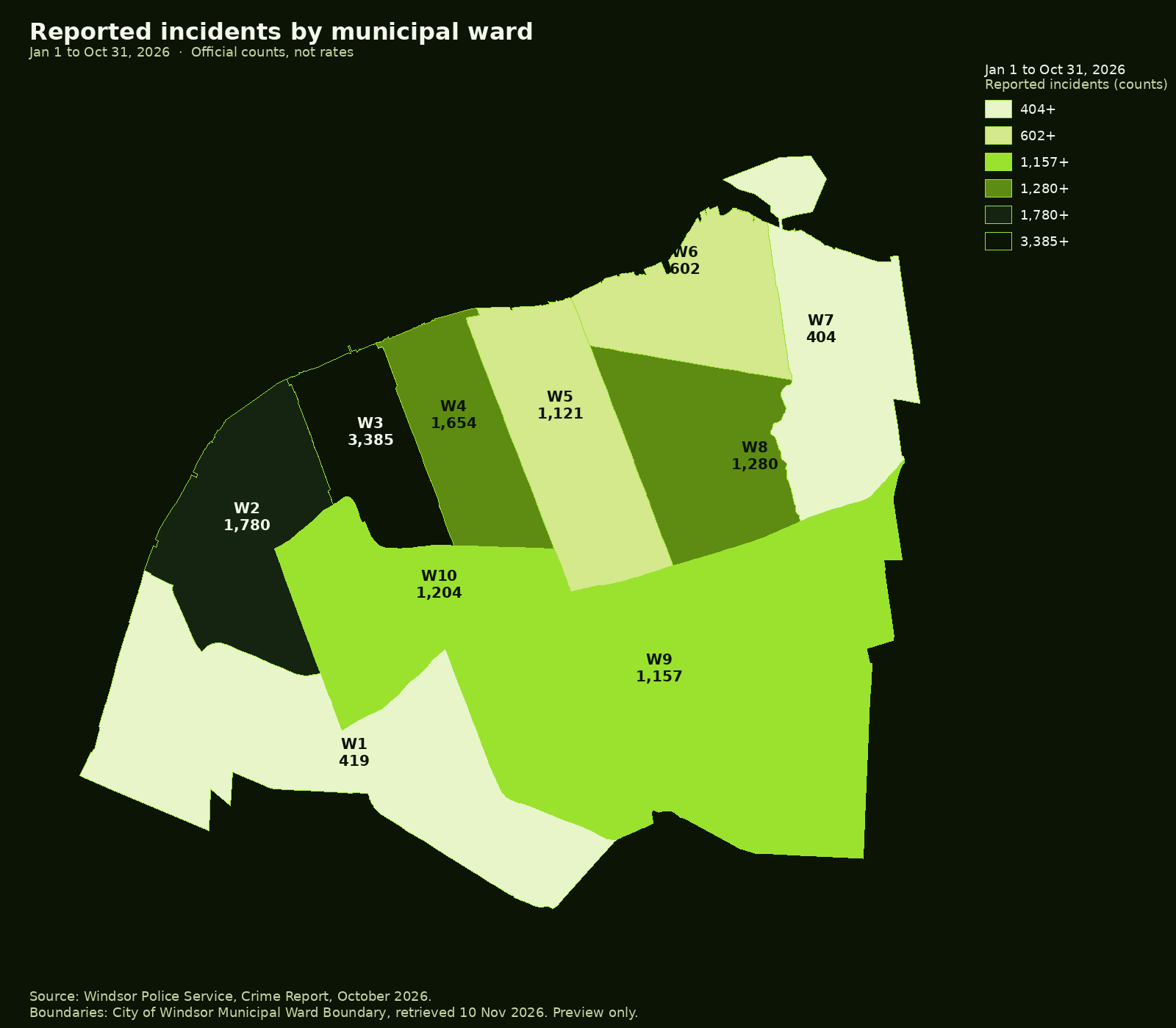
Ward boundaries: City of Windsor, Municipal Ward Boundary layer via mappmycity.ca, retrieved 10 November 2026. This page does not show councillor names from that file, because those attributes may be out of date. Other municipal boundaries and the Belle River point: OpenStreetMap / Nominatim, © OpenStreetMap contributors, ODbL, retrieved 10 November 2026. Incident counts: Windsor Police Service, October 2026 Crime Report, official 2026 figures only.
City and jurisdiction totals, 2026 only
These figures are official counts of reported incidents. This page does not show older years or year-over-year change.
| Area | October 2026 | Jan 1 to Oct 31, 2026 |
|---|---|---|
| Windsor Police jurisdiction, all | 1,401 | 13,881 |
| City of Windsor only | 1,350 | 13,364 |
| Town of Amherstburg | 50 | 486 |
Source: Windsor Police Service, Crime Report, October 2026, October 2026.pdf, retrieved 10 November 2026. Jurisdiction all includes the City of Windsor and the Town of Amherstburg, which the Windsor Police Service has policed since 1 January 2019. The report uses Statistics Canada UCR incident-based counting: an incident with more than one offence is counted once, under its most serious violation. Figures are reported incidents.
Municipal wards, City of Windsor
| Ward | October 2026, all | Jan 1 to Oct 31, 2026, all | Oct 2026, person | Jan 1 to Oct 31, 2026, person | Oct 2026, property | Jan 1 to Oct 31, 2026, property |
|---|---|---|---|---|---|---|
| Ward 1 | 52 | 419 | 18 | 92 | 23 | 225 |
| Ward 2 | 225 | 1,780 | 46 | 335 | 149 | 1,197 |
| Ward 3 | 320 | 3,385 | 59 | 572 | 196 | 1,931 |
| Ward 4 | 139 | 1,654 | 24 | 322 | 97 | 1,133 |
| Ward 5 | 104 | 1,121 | 21 | 192 | 66 | 754 |
| Ward 6 | 68 | 602 | 17 | 158 | 40 | 358 |
| Ward 7 | 29 | 404 | 7 | 121 | 15 | 232 |
| Ward 8 | 130 | 1,280 | 20 | 215 | 89 | 845 |
| Ward 9 | 108 | 1,157 | 12 | 125 | 82 | 896 |
| Ward 10 | 123 | 1,204 | 13 | 131 | 87 | 822 |
Ward totals for Jan 1 to Oct 31, 2026 add to 13,006 reported incidents. The City of Windsor only table lists 13,364 for the same period. The difference is 358. Ward October 2026 totals add to 1,298; the city-only October 2026 total is 1,350. This page reports each published 2026 table as printed and does not force the numbers to match.
Where official 2026 data is not yet published
- Official police per-capita rates by municipal ward: not yet published for 2026. Source: the October 2026 WPS Crime Report publishes counts, not rates, and does not include official 2026 population figures for each current ward. The optional "Per 1,000 residents" layer on this page uses mapped 2026 pins and 2021 Census populations instead, and is not an official police rate.
- Neighbourhoods inside a ward: not yet published for 2026. Source: the same report's finest official geography is the municipal ward, plus city-wide and Amherstburg tables.
- LaSalle municipal 2026 tables comparable to the WPS report: not yet published for 2026. Source: no official LaSalle Police or town open-data table of monthly 2026 reported incidents was found in the material reviewed by the desk, aside from the January 2026 snapshot already cited in Sources. Later months stay labelled "Data requested" on the map.
- OPP-policed Essex County municipalities (Lakeshore, including Belle River; Tecumseh; the Town of Essex; Kingsville; Leamington; and Pelee): comparable official monthly 2026 tables are not yet published for 2026 in the material reviewed by the desk, except the Town of Essex September 2026 detachment report already used in the map above. Those unpublished areas are hatched or greyed on the map and labelled "Data requested." This page does not backfill older numbers.
- November 2026 monthly and year-to-date figures: not yet published for 2026. Source: windsorpolice.ca/services/open-data, checked 11 November 2026.
Amherstburg's official 2026 counts appear in the same WPS report, are listed in the totals table above, and are shaded on the coverage map. When a later official 2026 release comes out, including for municipalities not yet published, the desk will add it here.